Benchmarks – the height of excellence
07/11/22
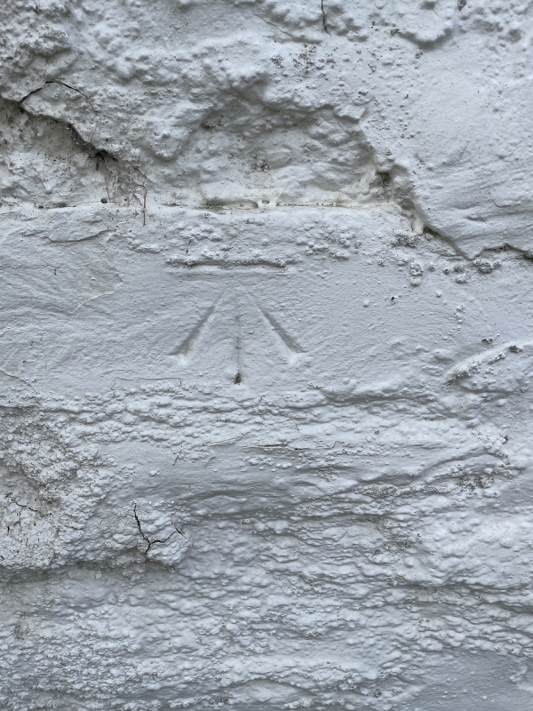
We often survey and work around all kinds of properties, from newer houses to older, heritage dwellings. When we were carrying out a survey recently, we found some interesting marks in the vicinity of the property. One of these is the unusual symbol depicted above. On the rear wall of a stone and timber frame cottage in Bucknall, we found this mark, which is very familiar to surveyors and builders, but may not be to the general public. The symbol is a benchmark. There used to be about half a million bench marks in Great Britain, to aid mapmaking, but they are not needed any more, due to GPS and satellite plotting. About half of them have now disappeared, but the practice has an interesting history and legacy.
Point to point
The term ‘benchmark’ (sometimes spelt bench mark) refers to the chiselled horizontal level mark that surveyors used to carve into stone structures. They are also sometimes depicted as a metal plate, but the most common ones – on everything from old cottages to churches – are carved into the stone exterior. The marks were made by Ordnance Survey. It used to be Ordnance Survey’s policy to maintain about five bench marks per one kilometre square in rural areas and about 30 to 40 in urban areas. There were also checks and efforts to renew the marks, to compensate for losses due to demolition, new buildings and roadworks.
The horizontal line on the benchmark denoted a specific height. An iron angle could be placed in the mark, to form a ‘bench’ or rest for a levelling rod. Using a level on a tripod and a levelling staff, this meant that every time a ‘level’ was taken from the symbol at that specific point, it would indicate the same height. The horizontal level marks are usually indicated with an upwards arrow below the line, ‘pointing’ to the spot (as depicted above on the cottage in Bucknall).
Highly accurate
The height of the benchmark is relative to other benchmarks in the area. There is a wide network of marks that are calculated using levels across a landscape, that originate from a ‘fundamental benchmark’. Fundamental benchmarks are very stable bench marks, with foundations built to minimise any movement, with a brass bolt set in the top of a granite pillar. They were built about 40 kilometres or 25 miles apart. These fundamental benchmarks were the key to levelling throughout the UK. They are highly accurate height stations still used today as the baseline of levelling. All these heights or elevations are relative to each other, so precise heights can be calculated for any given point nearby, high or low. This could be a ground level, for example, or foundation excavation depth. The fundamental benchmark is a level reading in metres that is a known relationship with the ‘vertical datum’ of the area. This is usually the height in relation to sea level. The position and height of each mark is indicated on large-scale maps.
Symbols of the past
Across the UK, Ordnance Survey is the agency responsible for mapping and logging these marks. UK benchmarks are usually found on the corners of pubs, churches and other public buildings, as well as old farm buildings, railway bridges and private houses, especially one sited near road junctions. However, any building may be used, as well as natural features such as walls, pillars or rock outcrops. Through they are dying out now as a form of levelling, they still enjoy a new lease of life as the basis for a hobby.
The widespread existence of benchmarks across the UK has given rise to the activity of benchmarking, or benchmark hunting. This involves enthusiasts searching for benchmarks using a handheld GPS receiver and logging their results online. It’s become popular since the advent of the internet and the free availability of such mapping data, from about 1995. If you have an old house, outbuildings or an estate, it’s worth having an explore and seeing if you have any benchmarks carved into them.


